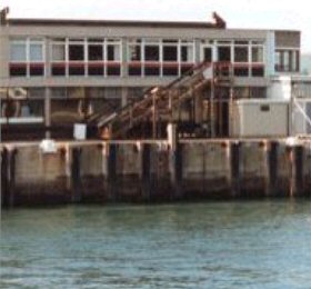
Weymouth tide gauge site
The Tide Gauge building is located on Commercial Pier adjacent to the ferry terminal. The pressure points are located on the pier
wall directly in front of the Tide Gauge building.
Click here
to see a map of the site in a separate window.
Tide gauge location
The GRP building houses the Tide Gauge equipment which consists of a POL data logger monitoring both pneumatic bubbler systems, and an Ott pneumatic chart recorder. The pressure points are mounted on steelwork which is attached to the pier wall.
 The tide gauge is levelled to the tide gauge bench mark supported by Ordnance Survey auxiliary marks.
External users
Sea level pressures and/or elevations from this site are supplied to the following authority:
- Weymouth Harbour
Site history
1990 – Two full tide pressure points installed and connected to an Ott chart recorder
1991 – DATARING data logger installed
2001 – POL data logger installed
| Location | |
| Latitude | 50° 36.51'N |
| Longitude | 2° 26.876'W |
| Grid ref | SY 6840 7885 |
| Earliest data | 1990 |
| Tidal levels | |
| HAT | 2.60 m |
| LAT | -0.30 m |
| MHWS | 1.40 m |
| MHWN | 1.21 m |
| MLWN | 0.84 m |
| MLWS | 0.20 m |
| H for 2024 | 2.60 m |
| L for 2024 | -0.30 m |
| H for 2025 | 2.49 m |
| L for 2025 | -0.21 m |
| MSR | 1.2 m |
| MNR | 0.37 m |
Abbreviations
HAT – highest astronomical tide
LAT – lowest astronomical tide
MHWS – mean high water springs
MHWN – mean high water neaps
MLWN – mean low water neaps
MLWS – mean low water springs
H – highest for year
L – lowest for year
MSR – mean spring range
MNR – mean neap range
Measurement devices
Tide gauge systemsFull-tide bubbler
Half-tide bubbler
Direct pressure transducer
Tide gauges
Ott pneumatic gauge
Munro float gauge
Wellhead float gauge
Lea float gauge
Instruments
DATARING logger
Datum probe