Port Ellen tide gauge site
The tide gauge is located within the Caledonian MacBrayne warehouse next to Port Ellen ferry terminal.
Click here
to see a map of the site in a separate window.
Tide gauge location
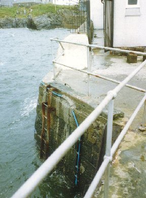
The warehouse is through the iron gate at the end of the wall. The pressure points are located on the opposite side of the pier to the ferry docking area. The steelwork supporting the blue tube which carries the air lines for the pressure points can be seen in the lower centre of the (Tide gauge location) picture.
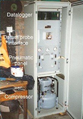
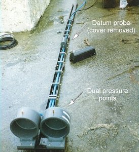 The tide gauge consists of a pneumatic bubbler system and datum probe. The bubbler supplies two full tide pressure points. The
monitoring equipment is housed in a heated cabinet within the CalMac warehouse. Both pressure lines and datum probe are monitored
by the POL data logger.
The tide gauge consists of a pneumatic bubbler system and datum probe. The bubbler supplies two full tide pressure points. The
monitoring equipment is housed in a heated cabinet within the CalMac warehouse. Both pressure lines and datum probe are monitored
by the POL data logger.
The tide gauge is levelled to the tide gauge bench mark supported by Ordnance Survey auxiliary marks.
External users
There are currently no external users.
Site history
1991 – DATARING system installed with two full-tide pressure points and datum probe
2005 – POL data logger installed
2012 – Site decommissioned due to harbour construction works, no date for reinstatement
| Location | |
| Latitude | 55° 37.656'N |
| Longitude | 6° 11.385'W |
| Grid ref | NR 3636 4508 |
| Earliest data | 1991 |
| Tidal levels | |
| HAT | 1.08 m |
| LAT | -0.30 m |
| MHWS | 0.78 m |
| MHWN | 0.54 m |
| MLWN | 0.42 m |
| MLWS | 0.12 m |
| H for 2024 | 1.08 m |
| L for 2024 | -0.25 m |
| H for 2025 | 1.04 m |
| L for 2025 | -0.20 m |
| MSR | 0.66 m |
| MNR | 0.12 m |
Abbreviations
HAT – highest astronomical tide
LAT – lowest astronomical tide
MHWS – mean high water springs
MHWN – mean high water neaps
MLWN – mean low water neaps
MLWS – mean low water springs
H – highest for year
L – lowest for year
MSR – mean spring range
MNR – mean neap range
Measurement devices
Tide gauge systemsFull-tide bubbler
Half-tide bubbler
Direct pressure transducer
Tide gauges
Ott pneumatic gauge
Munro float gauge
Wellhead float gauge
Lea float gauge
Instruments
DATARING logger
Datum probe