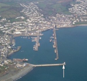
Newlyn tide gauge site
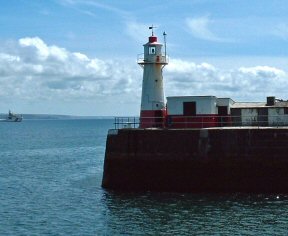
The Tidal Observatory is located at the end of South Pier, Newlyn next to the lighthouse, and the pressure points are located on
the seaward side of the pier behind the lighthouse.
Click here
to see a map of the site in a separate window.
Tide gauge location
Within the Tidal Observatory is a stilling well with a Munro float gauge and a pneumatic bubbler system supplying one full tide and one mid-tide pressure point.
 Both pressure lines and the Munro gauge potentiometer output are monitored by the POL data logger. Set
within the floor of the Observatory is the fundamental bench mark for the UK Geodetic Network.
Both pressure lines and the Munro gauge potentiometer output are monitored by the POL data logger. Set
within the floor of the Observatory is the fundamental bench mark for the UK Geodetic Network.
Click here for information about the significance of the Tidal Observatory.
External users
Sea level pressures and/or elevations from this site are supplied to the following authority:
- Environment Agency, South West Region
Site history
1915 – Cary Porter gauge operated by the Ordnance Survey
1983 – DATARING system with full-tide pressure point
1983 – Cary Porter gauge removed
1983 – Munro float gauge installed
1996 – Mid-tide pressure point installed
2001 – POL data logger installed
| Location | |
| Latitude | 50° 6.18'N |
| Longitude | 5° 32.57'W |
| Grid ref | SW 4676 2856 |
| Earliest data | 1915 |
| Tidal levels | |
| HAT | 6.13 m |
| LAT | 0.18 m |
| MHWS | 5.54 m |
| MHWN | 4.34 m |
| MLWN | 2.01 m |
| MLWS | 0.80 m |
| H for 2024 | 6.10 m |
| L for 2024 | 0.22 m |
| H for 2025 | 5.98 m |
| L for 2025 | 0.31 m |
| MSR | 4.74 m |
| MNR | 2.33 m |
Abbreviations
HAT – highest astronomical tide
LAT – lowest astronomical tide
MHWS – mean high water springs
MHWN – mean high water neaps
MLWN – mean low water neaps
MLWS – mean low water springs
H – highest for year
L – lowest for year
MSR – mean spring range
MNR – mean neap range
Measurement devices
Tide gauge systemsFull-tide bubbler
Half-tide bubbler
Direct pressure transducer
Tide gauges
Ott pneumatic gauge
Munro float gauge
Wellhead float gauge
Lea float gauge
Instruments
DATARING logger
Datum probe