Newhaven tide gauge site
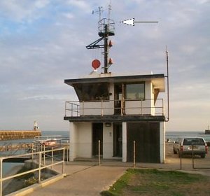
The tide gauge is located within the Port Control building on West Pier, Newhaven. The pressure points are located on the pier
wall, south west of the Port Control building. The anemometer and wind vane are located on the signals mast as shown.
Click here
to see a map of the site in a separate window.
Tide gauge location
The equipment which is housed in the switch room of the Port Control building consists of an Ott pneumatic gauge and a pneumatic bubbler system. The bubbler system supplies two full-tide pressure points which are mounted on steelwork attached to the pier wall.
 All three pressure lines, wind speed and direction are monitored by the POL data logger.
External users
Sea level pressures and/or elevations from this site are supplied to the following authority:
- Newhaven Port, port control
Site history
1990 – DATARING and bubbler system installed
1990 – Ott pneumatic gauge installed
1991 – Bubbler system removed due to harbour works
1992 – Bubbler system reinstated
1998 – Wind speed and direction instruments installed
2002 – POL data logger installed
| Location | |
| Latitude | 50° 46.907'N |
| Longitude | 0° 3.422'E |
| Grid ref | TQ 4511 0004 |
| Earliest data | 1990 |
| Tidal levels | |
| HAT | 7.32 m |
| LAT | 0.11 m |
| MHWS | 6.72 m |
| MHWN | 5.22 m |
| MLWN | 2.09 m |
| MLWS | 0.75 m |
| H for 2024 | 7.23 m |
| L for 2024 | 0.15 m |
| H for 2025 | 7.13 m |
| L for 2025 | 0.27 m |
| MSR | 5.97 m |
| MNR | 3.13 m |
Abbreviations
HAT – highest astronomical tide
LAT – lowest astronomical tide
MHWS – mean high water springs
MHWN – mean high water neaps
MLWN – mean low water neaps
MLWS – mean low water springs
H – highest for year
L – lowest for year
MSR – mean spring range
MNR – mean neap range
Measurement devices
Tide gauge systemsFull-tide bubbler
Half-tide bubbler
Direct pressure transducer
Tide gauges
Ott pneumatic gauge
Munro float gauge
Wellhead float gauge
Lea float gauge
Instruments
DATARING logger
Datum probe