Liverpool tide gauge site
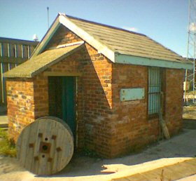
The tide gauge is located within the Old Lock Keeper's Office at the entrance to Gladstone Dock. The pressure points are located on
the seaward side of Gladstone Lock.
Click here
to see a map of the site in a separate window.
Tide gauge building
The tide gauge consists of a pneumatic bubbler system supplying two full tide pressure points. These are mounted on steelwork attached to an access ladder on the seaward side of the dock entrance. Both pressure lines, wind speed and direction are monitored by the POL data logger.
 The tide gauge is levelled to the tide gauge bench mark supported by Ordnance Survey auxiliary marks.
External users
Sea level pressures and/or elevations from this site are supplied to the following authority:
- Environment Agency, North West Region
Site history
1991 – DATARING system installed with two full tide pressure points and datum probe
1995 – Wind speed and direction instruments installed
2000 – POL data logger installed
2001 – Mid-Tide pressure point installed
2003 – Wind speed & direction instrument failed
| Location | |
| Latitude | 53° 26.981'N |
| Longitude | 3° 1.086'W |
| Grid ref | SJ 3248 9525 |
| Earliest data | 1991 |
| Tidal levels | |
| HAT | 10.37 m |
| LAT | 0.02 m |
| MHWS | 9.39 m |
| MHWN | 7.45 m |
| MLWN | 3.16 m |
| MLWS | 1.12 m |
| H for 2024 | 10.29 m |
| L for 2024 | 0.06 m |
| H for 2025 | 10.11 m |
| L for 2025 | 0.25 m |
| MSR | 8.27 m |
| MNR | 4.29 m |
Abbreviations
HAT – highest astronomical tide
LAT – lowest astronomical tide
MHWS – mean high water springs
MHWN – mean high water neaps
MLWN – mean low water neaps
MLWS – mean low water springs
H – highest for year
L – lowest for year
MSR – mean spring range
MNR – mean neap range
Measurement devices
Tide gauge systemsFull-tide bubbler
Half-tide bubbler
Direct pressure transducer
Tide gauges
Ott pneumatic gauge
Munro float gauge
Wellhead float gauge
Lea float gauge
Instruments
DATARING logger
Datum probe