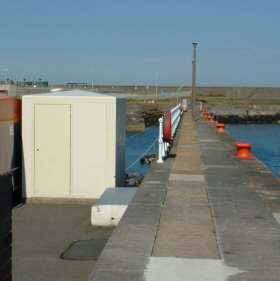
Fishguard tide gauge site
The Tide Gauge building is located on Fishguard Quay adjacent to the old railway sheds. The two full tide pressure points are
located approx 10m from the end of the quay. The mid-tide pressure point is about 20m from the tide gauge building.
Click here
to see a map of the site in a separate window.
Tide gauge location
The GRP building houses the tide gauge equipment which consists of a POL data logger monitoring both full tide sensors. The pressure points are mounted on steel work which is attached to the quay wall.
 The tide gauge is levelled to the tide gauge bench mark supported by Ordnance Survey auxiliary marks.
External users
Sea level pressures and/or elevations from this site are supplied to the following authority:
- Environment Agency Wales / Asiantaeth yr Amgylchedd Cymru
Site history
1959 – Lea gauge installed
1975 – Lea gauge moved to a new location near to the original due to harbour redevelopment of harbour
1988 – The tide gauge site closed down due to the redevelopment of the harbour. A new site was identified and a GRP tide gauge building was erected. The DATARING system was installed connected to two full-tide measuring systems located on the harbour wall.
2001 – POL data logger and mid-tide pressure point were installed
| Location | |
| Latitude | 52° 0.793'N |
| Longitude | 4° 59.027'W |
| Grid ref | SM 9534 3918 |
| Earliest data | 1959 |
| Tidal levels | |
| HAT | 5.50 m |
| LAT | 0.20 m |
| MHWS | 4.84 m |
| MHWN | 3.56 m |
| MLWN | 2.00 m |
| MLWS | 0.83 m |
| H for 2024 | 5.48 m |
| L for 2024 | 0.20 m |
| H for 2025 | 5.36 m |
| L for 2025 | 0.29 m |
| MSR | 4.01 m |
| MNR | 1.56 m |
Abbreviations
HAT – highest astronomical tide
LAT – lowest astronomical tide
MHWS – mean high water springs
MHWN – mean high water neaps
MLWN – mean low water neaps
MLWS – mean low water springs
H – highest for year
L – lowest for year
MSR – mean spring range
MNR – mean neap range
Measurement devices
Tide gauge systemsFull-tide bubbler
Half-tide bubbler
Direct pressure transducer
Tide gauges
Ott pneumatic gauge
Munro float gauge
Wellhead float gauge
Lea float gauge
Instruments
DATARING logger
Datum probe