Dover tide gauge site
The tide gauge is located just before the lighthouse at the end of Prince of Wales Pier, Western Dock.
Click here
to see a map of the site in a separate window.
Tide gauge location
The tide gauge equipment is housed in a GRP building and consists of a pneumatic bubbler system with two full tide and mid-tide pressure points mounted on steelwork attached to the stilling well which once supported a Munro float gauge before the installation of a two bubbler.
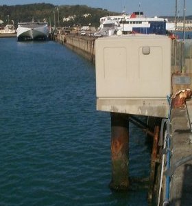 All three pressure lines are monitored by the POL data logger.
External users
There are currently no external users.
Site history
1894 – Cary Porter gauge in use
1959 – Type No. 1 Lea gauge installed
1965 – Munro gauge installed
1976 – Building being demolished due to site refurbishment
1978 – Munro gauge installed in new building
1986 – Wellhead unit installed
1986 – DATARING installed using the Munro and Wellhead unit
1996 – Wellhead unit removed from service
1996 – Temporary full tide bubbler installed prior to site refurbishment
1997 – Munro gauge removed from service
1997 – Two full tide and a mid-tide bubbler system installed
2000 – POL data logger installed
| Location | |
| Latitude | 51° 6.864'N |
| Longitude | 1° 19.356'E |
| Grid ref | TR 3264 4026 |
| Earliest data | 1894 |
| Tidal levels | |
| HAT | 7.27 m |
| LAT | 0.24 m |
| MHWS | 6.69 m |
| MHWN | 5.40 m |
| MLWN | 2.14 m |
| MLWS | 0.87 m |
| H for 2024 | 7.22 m |
| L for 2024 | 0.27 m |
| H for 2025 | 7.13 m |
| L for 2025 | 0.38 m |
| MSR | 5.82 m |
| MNR | 3.26 m |
Abbreviations
HAT – highest astronomical tide
LAT – lowest astronomical tide
MHWS – mean high water springs
MHWN – mean high water neaps
MLWN – mean low water neaps
MLWS – mean low water springs
H – highest for year
L – lowest for year
MSR – mean spring range
MNR – mean neap range
Measurement devices
Tide gauge systemsFull-tide bubbler
Half-tide bubbler
Direct pressure transducer
Tide gauges
Ott pneumatic gauge
Munro float gauge
Wellhead float gauge
Lea float gauge
Instruments
DATARING logger
Datum probe