Bangor tide gauge site
The Bangor (Northern Ireland) tide gauge building and pressure points are located on Central Pier at Bangor Marina. The pressure
points are on the seaward side of the open pier directly beneath the tide gauge building.
Click here
to see a map of the site in a separate window.
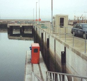
Tide gauge location
The tide gauge equipment is housed in a GRP building. The pneumatic bubbler system consists of two full tide and mid-tide pressure points mounted on steelwork attached to one of the pier supports. All three pressure lines are monitored by the POL data logger.
 The tide gauge is levelled to the tide gauge bench mark supported by Ordnance Survey of Northern Ireland auxiliary marks.
External users
There are currently no external users.
Site history
1994 – DATARING system installed with two full tide and mid-tide bubblers
2000 – The tide gauge system was shut down prior to the commencement of harbour works
2001 – DATARING system restarted
2001 – New POL data logger installed recording the two full tide sensors
2003 – Mid-tide sensor connected to the POL data logger
| Location | |
| Latitude | 54° 39.882'N |
| Longitude | 5° 40.17'W |
| Grid ref | J 502822 (OSNI) |
| Earliest data | 1994 |
| Tidal levels | |
| HAT | 3.88 m |
| LAT | 0.11 m |
| MHWS | 3.46 m |
| MHWN | 2.98 m |
| MLWN | 1.11 m |
| MLWS | 0.56 m |
| H for 2024 | 3.81 m |
| L for 2024 | 0.11 m |
| H for 2025 | 3.76 m |
| L for 2025 | 0.17 m |
| MSR | 2.9 m |
| MNR | 1.87 m |
Abbreviations
HAT – highest astronomical tide
LAT – lowest astronomical tide
MHWS – mean high water springs
MHWN – mean high water neaps
MLWN – mean low water neaps
MLWS – mean low water springs
H – highest for year
L – lowest for year
MSR – mean spring range
MNR – mean neap range
Measurement devices
Tide gauge systemsFull-tide bubbler
Half-tide bubbler
Direct pressure transducer
Tide gauges
Ott pneumatic gauge
Munro float gauge
Wellhead float gauge
Lea float gauge
Instruments
DATARING logger
Datum probe