Maintenance and development of operational tide-surge models
The National Oceanography Centre Liverpool works with the Met Office to develop storm surge forecasting models for the Environment Agency.
Tide-surge models are run in real-time as part of the forecast suite of models at the Met Office. Results are transmitted to the Environment Agency and used together with data from the National Tide Gauge Network for coastal flood warning.
The current system uses the NEMO model run on the 7-km Atlantic Margin model domain (AMM7). Surge models run four times per day producing forecasts up to two days ahead. Ensemble forecasts ( engineers only) are also available for advanced predictions six days ahead. The model surge residual (the change in water level due to the weather) is combined with tides predicted at individual tide gauge sites to give the best estimate of the total water level.
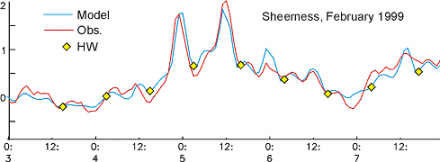
Model performance is routinely monitored at the National Oceanography Centre Liverpool by comparing forecast results with observations every month. Typical root-mean-square errors are about 10cm. Significant forecast errors are investigated and causes diagnosed so that the system can be progressively improved.
The history of storm surge forecasting
Prior to 2021, the system comprised of a 12-km shelf model (CS3X), with refinements to 1km and a 1-D river model in the complex regime of the Bristol Channel and Severn Estuary.
The first operational surge forecasts were run in 1978 using coarse grid surge and atmospheric models. Early models were dedicated computers built especially for the task, including this machine on display at the Science Museum in London.
Storm surge animations

View zoomed-in animations for:
Water level 15-min interval forecast
Surge level 15-min interval forecast
Surge animation (15-minute interval)
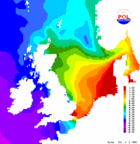
This 2½-day forecast animation shows the total water level of tide plus storm surge progressing around the coast of the UK. The highest water level is coloured red, while the lowest level is coloured dark blue. If a high tide occurs during a large positive surge then coastal flooding is likely.
Surge animation (15-minute interval)

This 2½-day forecast animation shows a storm surge progressing around the coast of the UK. The largest positive surge is coloured dark magenta, while the largest negative surge is coloured dark green. If a high tide occurs during a large positive surge then coastal flooding is likely.
Surge model outputs
View the lastest surge forecasts at tide gauges from the UK operational storm surge model.